DocuClip Studio › Historical atlas map animator
Browser tool
A historical atlas map animator for history videos
A history video usually needs the map of its own time: the Roman Empire in 117, Europe in 1815, the world in 1942. DocuClip Studio has the borders of ten eras built in and animates them in an atlas style, so the map of your period is ready before you add the routes and the dates.
⚡ Customize This Sample Free in Studio (Sign In Free) →
Opens the Constantinople 1453 sample in the studio after a free sign-in (e-mail sign-in, no card).
Ten eras, built in
Choose an era and its borders are drawn: 2000 BC, 117 AD, 1200, 1492, 1815, 1914, 1938, 1942, 1989 and today. The five public eras are part of every plan, including the free preview; the conquest eras from 1815 to 1989, with their invasion and alliance arrows, come with Creator and Studio Pro. Borders can appear with a conquest sweep or be traced along their line, so a change of territory is shown rather than just stated.
The atlas look
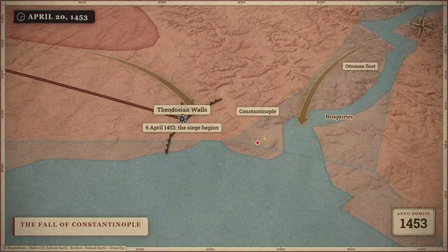
The parchment atlas style draws the land on a vellum texture with soft relief from elevation data, quiet seas and three engraved lines along every coast, the way old printed atlases marked shorelines. Campaign routes follow smooth curves between their stops instead of straight segments, and a year counter can tick along with the camera. Other looks, such as a dark geopolitics map or a blueprint schematic, are one click away if the atlas feels too warm for your story.
The sample
The sample on this page is a historical campaign map: the camera moves across the region as the routes draw and the labels appear, with paper textures and a whip pan between scenes. Open it, change the era, the stops and the labels, and re-time each part on the timeline to your narration. Nothing has to be keyframed by hand, although you can keep any camera position as a keyframe.
Accuracy and sources
Historical borders are approximate by nature: many frontiers were zones rather than lines, and maps of the same year disagree. The era borders are simplified and meant for storytelling at the scale of countries and empires. For a claim that depends on an exact frontier, check a scholarly atlas and say on screen which one you followed. Modern borders that are disputed are drawn as they are commonly mapped; hatching can mark a contested area.
From script to map
Type a line such as “Napoleon’s march from Paris to Moscow, 1812 (10s)” into the prompt bar and the route and the timing are drafted for you; then adjust what you do not like. On Studio Pro, Script-to-B-Roll reads a whole narration and proposes a map, press or chart scene for every place and date it finds.
Export and plans
History maps export as MP4 in 16:9, 9:16 or 1:1. Creator exports 1080p at up to 60 fps, clips up to 60 seconds; Studio Pro exports 4K at 60 fps, up to 10 minutes, with the 3D Globe and transparent alpha. The free Free Explorer previews every era in the studio under a watermark and exports no files.
How it compares
| Feature | DocuClip Studio | Scanned historical atlas | Map plugin in After Effects |
|---|---|---|---|
| Borders of the period | 10 built-in eras, from 2000 BC to today | Exactly the atlas’s own, as printed | Imported as your own data |
| Animation | Conquest sweeps, border traces, campaign routes and a year counter | Pan and zoom over a still image | Keyframed by hand |
| Look | Parchment atlas with relief and engraved coastlines, or other styles | The atlas’s own engraving | Whatever you design |
| Changes | Change the era or a stop and the scene redraws | Find another scan | Edit layers and keyframes |
| Rights | Built-in data licensed for use in your exports | Check the copyright of the scan | Depends on the data you import |
Last reviewed November 2026. This comparison describes how each product works, not its price, and is not based on hands-on benchmarks. Features change, so check the vendor’s own site before you decide. Product names belong to their owners; DocuClip Studio is not affiliated with them.
When another tool is better. A scan of a real historical atlas is the better choice when the historical document itself is the point, for example to show how mapmakers of the time saw the world. After Effects is better for a fully custom design.
Questions
- Which eras are included?
- 2000 BC, 117 AD, 1200, 1492, 1815, 1914, 1938, 1942, 1989 and today. The conquest eras from 1815 to 1989 and their arrows come with a paid plan.
- Are the borders exact?
- They are approximate, at the scale of countries and empires, and meant for storytelling. Check a scholarly atlas for any claim that depends on an exact frontier.
- Can I draw a campaign route?
- Yes. Add the stops, or type the route as a sentence, and the route draws along a smooth curve with labels and an optional year counter.
- Is it free to try?
- Yes. A Free Explorer account opens and previews every era under a watermark at 540p. Exports start with Creator at $19 a month.
Free to explore, paid to export
- Free Explorer ($0): a free account (e-mail sign-in), no card. Every sample and engine in a watermarked 540p preview at 24 fps (globe scenes are shown flat), 3 custom AI prompts and the pre-rendered sample NLE pack; no file exports.
- Creator ($19 a month or $149 a year): watermark-free 1080p exports at up to 60 fps (no export credits; fair use applies), clips up to 60 seconds, for your own channels.
- Studio Pro ($49 a month or $299 a year): 4K at 60 fps, exports up to 10 minutes, the 3D Globe, transparent alpha, batch NLE packs, smart reframe and After Effects .jsx bundles, for client work too.
⚡ Customize This Sample Free in Studio (Sign In Free) → Compare the plans