DocuClip Studio › Templates › Geopolitics › Instagram Reels
Belt and Road Initiative Map for Instagram Reels
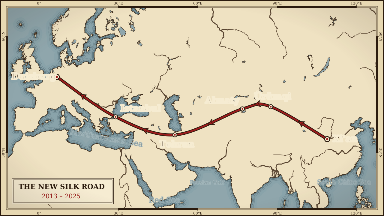
Map the rail corridor from central China to the Rhine in a clean explainer style. It opens ready for Instagram Reels: vertical 9:16, 9 seconds, nothing to resize.
⚡ Customize This Sample Free in Studio (Sign In Free) →Runs in your browser · Free Explorer: a free account (e-mail sign-in), no card · rendered on your device
The problem
Infrastructure stories span a dozen countries, and a list of them puts audiences to sleep.
Template apps give every account the same look, and real motion design tools were never built for phones or tight turnarounds.
And every hour spent wrestling keyframes is an hour not spent on the script, which is the part viewers actually came for.
The fix
DocuClip opens with a line running from Xi'an through Ürümqi, Almaty, Tehran and Istanbul to Duisburg on a quiet grey map, already composed for Instagram Reels at 1080 × 1920.
Everything on screen is editable: swap the text, drag the camera, restyle the look. The motion stays smooth because it is generated, not hand-keyed.
Match the colour grade to your feed, keep the camera move slow, and end on a frame that works as the cover image.
When it looks right, press Export MP4. The video is rendered frame by frame on your own computer, so it is never uploaded and there is no render queue.
What is inside this template
Reels audiences save and share polished explainers, and a cinematic graphic is what makes a post feel worth saving.
Real 3D camera
Cinematic fly-to, orbit and smooth pan-zoom moves with tilt and bearing, eased between keyframes you can drag on the timeline.
Historical borders
Loads with the modern borders already on the map, with adjustable fill, glow and labels.
Geodesic routes
6-stop great-circle route with a moving glowing dot, a live distance counter and a year counter.
Four atlas looks
Vintage Parchment Atlas, Dark Ops Geopolitics, Clean Documentary Minimal and Old Sepia Chronicle, applied to key-free OpenFreeMap vector tiles.
Arrows and markers
Pulsing invasion arrows, dashed alliance links and glowing markers that pop in on cue.
Offline place search
Find modern cities and ancient sites instantly, or click the map to pin a stop. No map API key, ever.
How to make a Belt and Road Initiative Map in three steps
- Open the templatePress the button above and sign in free with an e-mail code. The map animation loads in your browser with the vertical 9:16 frame and 9-second timing already set.
- Make it yoursSearch for your own places, pick an era and a map style, and drag the camera keyframes.
- Export the MP4Click Export MP4. Exports start with Creator: clean 1080p at up to 60 fps, clips up to 60 seconds (subject to fair use); Studio Pro adds 4K at 60 fps and exports up to 10 minutes, ideal for vertical feeds. The free account previews it with a watermark.
| Engine | 3D Map Animator |
|---|---|
| Format | Instagram Reels · vertical 9:16 · 1080 × 1920 |
| Length | 9 seconds (adjustable; exports up to 60 s on Creator and up to 10 minutes on Studio Pro) |
| Export | H.264 MP4, rendered frame by frame on your device. Free Explorer: a watermarked 540p preview, no file exports · Creator: 1080p60 (subject to fair use) · Studio Pro: 4K60, transparent alpha and PNG sequences |
| Price | Free preview with a free account · Creator $19 a month or $149 a year · Studio Pro $49 a month or $299 a year · see all plans |
Questions
Is this Belt and Road Initiative Map template really free?
Opening, editing and previewing it are. With a Free Explorer account (free: e-mail sign-in, no card) you can open it, edit everything and play the full preview, watermarked at up to 540p and 24 fps, and run 3 custom AI prompts; the free account exports no files. Its preview shows every Studio Pro scene feature and effect, under a watermark (the conquest eras come with a paid plan), with globe scenes shown flat. Creator ($19 a month or $149 a year) exports clean 1080p at up to 60 fps, clips up to 60 seconds (subject to fair use); Studio Pro ($49 a month or $299 a year) adds 4K at 60 fps, exports up to 10 minutes, the 3D Globe, transparent alpha exports, the Script-to-B-Roll batch studio and timeline packs. Paid plans can be cancelled at any time. Refunds within 14 days are reviewed case by case under Paddle’s refund policy; statutory withdrawal rights always apply.
Will it fit Instagram Reels without cropping?
Yes. This page opens the vertical 9:16 version (1080 × 1920), timed to 9 seconds. Turn on the safe-zone guides to keep labels clear of the platform buttons.
Do I need a Google Maps or Mapbox API key?
No. The maps use open OpenStreetMap data served by OpenFreeMap, plus bundled Natural Earth data for the historical borders and the built-in place search. There is no map key to set up and no usage bill.
Does my video get uploaded anywhere?
No. DocuClip is a client-side app: the animation is drawn and encoded to H.264 MP4 inside your browser using WebCodecs. Your images, article text and chart data stay on your device; only a prompt you type into the AI prompt bar is sent to our server to plan the scene, and it is not stored.
How long does a 9-second export take?
It depends on your computer, the resolution and the frame rate, and the export dialog shows the time left while it runs. Because every frame is rendered offline rather than screen-recorded, a slower computer takes longer but produces exactly the same smooth result.
Can I use the videos commercially?
Yes, on a paid plan. Creator's licence covers one creator's own monetised YouTube, Shorts, TikTok and social channels; client, freelance and agency work needs Studio Pro, whose licence covers unlimited channels and client deliverables. Both licences are revoked on refund or chargeback, for the exports made under the refunded or charged-back payment. The free account exports no files; its preview is for personal evaluation only. For maps, keep the small data credit in the frame or credit OpenStreetMap contributors in your description.
Same scene, other formats
- Belt and Road Initiative Map for a YouTube Documentary
- Belt and Road Initiative Map for YouTube Shorts
- Belt and Road Initiative Map for TikTok
- Belt and Road Initiative Map for a Faceless History Channel
- Belt and Road Initiative Map for a Square Social Post
- Belt and Road Initiative Map for a Video Essay
- Belt and Road Initiative Map for a Classroom Lesson
- Belt and Road Initiative Map for a Podcast Clip
- Belt and Road Initiative Map for a News Explainer
More Geopolitics templates for Instagram Reels
- Geopolitical Oil Routes Map
- NATO Expansion Map Animation
- Travel Flight Route Map Animation
- Military Budget Bar Chart Race
- Cuban Missile Crisis Map
- Berlin Airlift Map Animation
Pair it with
Ready when you are
Open it, change the words, export. That is the whole workflow.
⚡ Customize This Sample Free in Studio (Sign In Free) →